![Item #001004 Pennsylvania Showing Counties in Different Colors--Townships--Cities--Boroughs--Villages Post Offices--Steam and Electric Railways, with Stations and Distances between Stations [map]](https://classicbooksandephemera.cdn.bibliopolis.com/pictures/001004.jpg?width=768&height=1000&fit=bounds&auto=webp&v=1472068465)
![Pennsylvania Showing Counties in Different Colors--Townships--Cities--Boroughs--Villages Post Offices--Steam and Electric Railways, with Stations and Distances between Stations [map]](https://classicbooksandephemera.cdn.bibliopolis.com/pictures/001004_2.jpg?auto=webp&v=1472068465)
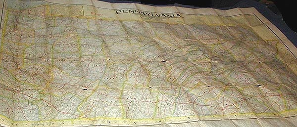
Pennsylvania Showing Counties in Different Colors--Townships--Cities--Boroughs--Villages Post Offices--Steam and Electric Railways, with Stations and Distances between Stations [map]
Indianapolis, Ind. National Map Co., 1922. One map (approx. 126 x 156 cm.) printed in color. Folded to fit in a black case (21 x 13 cm.) with text inside the front describing the pubisher's National Series of Commercial Maps. Population data taken from 1920 census, indicating publication in the 1920s. 1922 as the year of publication is based on library records. The "Main Travelled Roads," described in the text as "the principal automobile highways," are shown in red on the map. This was a very important feature for the driver at this time, before uniform highway signage. In Very Good+ Condition: lower corner of front of case creased; some separations starting along folds of map, which is entirely intact. Very Good +. Item #001004
Price: $95.00