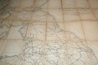
Cheffins's Map of the Railways in Great Britain: From the Ordnance Surveys
London: Chas. F. Cheffins, 1848. Map. "Published by Chas. F. Cheffins, 9 Southampton Buildings, Holborn. And W.S. Orr & Co. Paternoster Row. Also by Wareing Webb, Castle Street, Liverpool." 1 map: handcolored engraved map; dissected and mounted on linen; 126 x 96 cm., folded to 20 x 13 cm. Scale..... More